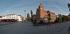
Zeist
| |||||
 | |||||
| Państwo | |||||
|---|---|---|---|---|---|
| Prowincja | |||||
| Burmistrz | Koos Janssen (2014)[1] | ||||
| Powierzchnia | 38,64 km² | ||||
| Populacja (2013) • liczba ludności • gęstość | 66 081}[2] 1710,17 os./km² | ||||
| Nr kierunkowy | 030 | ||||
| Kod pocztowy | 3700-3704 | ||||
 | |||||
| Strona internetowa | |||||
Zeist – miasto w Holandii, leżące nieopodal Utrechtu w prowincji Utrecht. Ma 65 396 mieszkańców (2012).
W mieście rozwinął się przemysł metalowy, chemiczny, optyczny oraz spożywczy[3].
Ludzie związani z Zeist
Przypisy
- ↑ zeist.nl: Burgemeester (niderl.). [dostęp 2014-07-12]. [zarchiwizowane z tego adresu (2014-04-13)].
- ↑ World Gazetteer}
- ↑ Zeist, [w:] Encyklopedia PWN [online] [dostęp 2021-08-29].
Media użyte na tej stronie
Coat of arms of the Dutch municipality of Zeist.
Autor: User:Steinbach, Licencja: CC-BY-SA-3.0
Location of Zeist, Netherlands, within the province of Utrecht
Flag of Zeist, Utrecht, the Netherlands.
Autor: Wouter Hagens, Licencja: CC BY-SA 3.0
On the right the townhall, on the left restaurant Hermitage in Zeist
Autor: Erik Frohne, Licencja: CC BY-SA 3.0
Location map of province Utrecht in the Netherlands
Equirectangular projection, N/S stretching 163 %. Geographic limits of the map:
- N: 52.40° N
- S: 51.90° N
- W: 4.70° E
- E: 5.70° E


