2008TC3-groundpath-rev
Autor:
George William Herbert (graphic overlay) / US Government (original map)
Credit:
Own work modifications to US Government PD / CIA Factbook map of Sudan
Krótki link:
źródło:
Wymiary:
537 x 579 Pixel (238006 Bytes)
Opis:
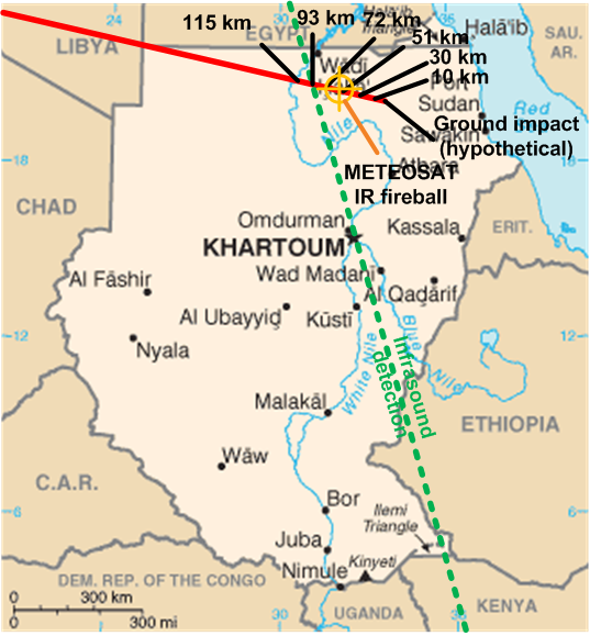
Ground track and probable explosion point in midair of the asteroid 2008 TC3 which entered earth's atmosphere and exploded over Sudan on 2008-10-06.
Original map CIA Factbook. Graphic overlay George William Herbert 2008-10-07. GFDL and CC-BY-3.0 dual licensed.
Ground track from Very near NEO Meteoroid (Mike Kretlow); infrasound track from [1] (Dr Peter Brown); IR fireball location from [2] and [3] (EUMETSAT). The infrasound map image can also be found at [4].![[1]](http://www.minorplanets.org/OLS/images/map-prelim.jpg)
![[2]](http://www.eumetsat.int/groups/ops/documents/image/img_asteroid_impact_hrv.jpg)
![[3]](http://www.eumetsat.int/groups/ops/documents/image/img_asteroid_impact_nat_cols.jpg)
Licencja:
Public domain
Więcej informacji o licencji można znaleźć tutaj. Ostatnia aktualizacja: Wed, 21 Sep 2022 18:16:06 GMT