Balkans925
Autor:
Credit:
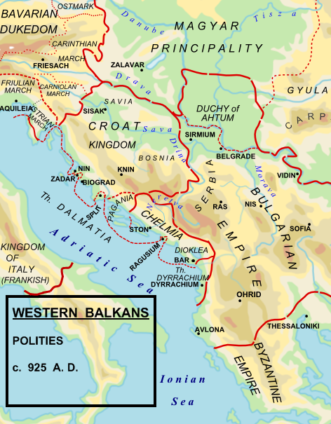
Made by Hxseek using the following sources:
- Map from: en:File:Roman Empire 125.svg by Andrei nacu
- Info from:
- (1) The Early Medieval Balkans. A Critical Survey from the Sixth to the Late Twelfth Century. J V A Fine, Jr. Pg 262:
- To the south of the Drava, he (King Tomislav)held what we think of modern Croatia, Slavonia, northern and western Bosnia, and the territory along the Dalmatian coast to the mouth of the Cetina river (excluding scattered Byzantine towns)
- (2) The Balkans. From Constantinople to Communism. D P Hupchik. Map 3, depicts Croatia to extend approximately to the Drina river.
- (3) Shepherds Historical Atlas.
Krótki link:
źródło:
Wymiary:
472 x 605 Pixel (230158 Bytes)
Opis:
Political map of the western Balkan in 925 AD.
Licencja:
Public domain
Komentarz do licencji:
| Ten utwór został udostępniony jako własność publiczna przez jego autora, Hxseek. Dotyczy to całego świata. W niektórych krajach może nie być to prawnie możliwe, jeśli tak, to: Hxseek zapewnia każdemu prawo do użycia tej pracy w dowolnym celu, bez żadnych ograniczeń, chyba że te ograniczenia są wymagane przez prawo. |
Więcej informacji o licencji można znaleźć tutaj. Ostatnia aktualizacja: Wed, 19 Oct 2022 16:33:41 GMT