Bay-of-Piran maritime-boundary-dispute
Autor:
- BorderDispute_BayOfPiran_blank.png: Captain Blood
- derivative work: AnonMoos
Attribution:
Obraz jest oznaczony jako „Wymagane uznanie autorstwa” (attribution required), ale nie podano żadnych informacji o uznaniu autorstwa. Prawdopodobnie parametr atrybucji został pominięty podczas korzystania z szablonu MediaWiki dla licencji CC-BY. Autorzy mogą znaleźć tutaj przykład prawidłowego korzystania z szablonów.
Krótki link:
źródło:
Wymiary:
709 x 600 Pixel (164071 Bytes)
Opis:
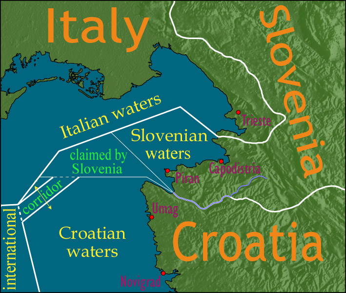
Map showing a diplomatic dispute resulting from Slovenia's desire to obtain a direct corridor from its own territorial waters to international waters, to avoid the necessity of Slovenian ships having to sail through the territorial waters of any other country to get to the high seas. Slovenia's only seacoast is in the Bay of Piran / Gulf of Trieste (as shown in this map), and its only commercial seaport is Capodistria / Koper (the eastern of the two red dots in Slovenia on this map), while Italy and Croatia both have long seacoasts outside the area shown in this map.
Slovenia's claim to the area labelled with green text, and the existence of a corridor to international waters, would have been allowed by Croatia under the Drnovšek-Račan agreement, but this was never ratified by either countries' parliaments.
This is an English version of image de:Bild:Grenzstreit-Bucht-von-Piran.jpg, created using image Image:BorderDispute_BayOfPiran_blank.png.
Raw Adobe Photoshop PSD files (with all text on different type layers) are available on request.
Licencja:
Komentarz do licencji:
The underlying source Image:BorderDispute_BayOfPiran_blank.png is declared to be GFDL, while I declare my changes to it to be PD.
Warunki licencji:
Creative Commons Attribution-Share Alike 3.0
Więcej informacji o licencji można znaleźć tutaj. Ostatnia aktualizacja: Sun, 16 Jan 2022 10:42:27 GMT