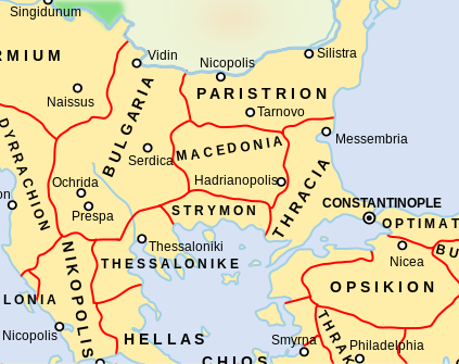
Byzantine Macedonia 1045CE
Autor:
Attribution:
Obraz jest oznaczony jako „Wymagane uznanie autorstwa” (attribution required), ale nie podano żadnych informacji o uznaniu autorstwa. Prawdopodobnie parametr atrybucji został pominięty podczas korzystania z szablonu MediaWiki dla licencji CC-BY. Autorzy mogą znaleźć tutaj przykład prawidłowego korzystania z szablonów.
Credit:
This is a derivative work of a more complete map created by Andrei Nacu of the English Wikipedia.
Krótki link:
źródło:
Wymiary:
423 x 335 Pixel (416958 Bytes)
Opis:
A map showing the Byzantine themata (administrative units) of the Byzantine Empire in 1045 CE, focusing on central Balkans around the region of Macedonia. The Macedonian thema is in what today is part of present-day Bulgaria, while the Bulgarian thema includes what today is the Republic of Macedonia. Note that the thematic boundaries in this map, especially those of Strymon and Macedonia, are very inaccurate. Macedonia was catually located further south, up to the Aegean coast of western Thrace
Licencja:
Komentarz do licencji:
GFDL-1.2+, CC-BY-SA-3.0/2.5/2.0/1.0
Warunki licencji:
Creative Commons Attribution-Share Alike 4.0
Więcej informacji o licencji można znaleźć tutaj. Ostatnia aktualizacja: Tue, 22 Nov 2022 19:56:11 GMT
