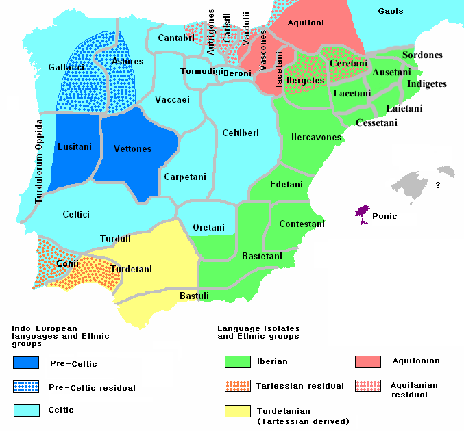
Ethnographic Iberia 200 BCE
Autor:
Attribution:
Obraz jest oznaczony jako „Wymagane uznanie autorstwa” (attribution required), ale nie podano żadnych informacji o uznaniu autorstwa. Prawdopodobnie parametr atrybucji został pominięty podczas korzystania z szablonu MediaWiki dla licencji CC-BY. Autorzy mogą znaleźć tutaj przykład prawidłowego korzystania z szablonów.
Credit:
self-made from Image:Blank-peninsula Iberica.png
Krótki link:
źródło:
Wymiary:
677 x 630 Pixel (60219 Bytes)
Opis:
Ethnographic and Linguistic Map of the Iberian Peninsula at about 200 BCE (at the end of the Second Punic War). Based on the map done by Portuguese Archeologist Luís Fraga (luisfraga@arqueotavira.com), from the "Campo Arqueológico de Tavira" (Tavira Archeological Camp - official site), in Tavira, Algarve - Portugal. The reference map can be found at this location, and a pdf version, with extensive and detailed information on the criteria used, as well as the long bibliography used to source the map can be found here.
Licencja:
Warunki licencji:
Creative Commons Attribution-Share Alike 4.0
Więcej informacji o licencji można znaleźć tutaj. Ostatnia aktualizacja: Thu, 10 Nov 2022 01:17:43 GMT