G-F triangulation
Autor:
Credit:
Libellus de locorum describendorum ratione. This scan found at [1]
![[1]](http://www.math.yorku.ca/SCS/Gallery/images/G-F_triangulation.jpg)
Krótki link:
źródło:
Wymiary:
272 x 400 Pixel (21941 Bytes)
Opis:
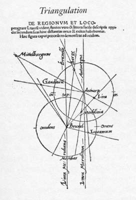
Gemma Frisius's 1533 diagram introducing the idea of triangulation into the science of surveying. Having established a baseline, eg the cities of Brussels and Antwerp, the location of other cities, eg Middelburg, can be found by taking its compass direction at each end of the baseline, and plotting where the two directions cross. Note that this was only a theoretical presentation of the concept -- because of hills etc, it is in fact actually impossible to see Middelburg from either Brussels or Antwerp! Nevertheless, the figure soon became well known all across Europe.
Licencja:
Public domain
Więcej informacji o licencji można znaleźć tutaj. Ostatnia aktualizacja: Thu, 22 Apr 2021 00:00:03 GMT