Inner german border diagram 1960s
Autor:
Ministerium für Bundesangelegenheiten, Vertriebene und Flüchtlinge
Credit:
Scan of original leaflet
Krótki link:
źródło:
Wymiary:
1596 x 1122 Pixel (342737 Bytes)
Opis:
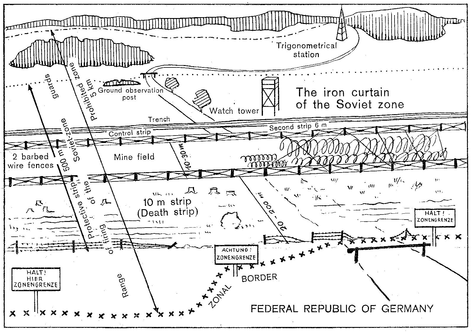
Extract from an English-language leaflet given to visitors to the en:Inner German border by West German border guards in Lower Saxony, depicting the configuration of the border as it was in the early 1960s.
Schematic diagram depicting the inner German border system of the 1960s as seen from West Germany. The border cuts across a road which formerly linked east and west. In the foreground, Federal Republic of Germany territory with signposts marking the zonal border and a road ending in a gate just before the zonal border; a variable distance behind the zonal border, in Soviet zone territory, there is first a fence, then a 20- to 200-metre cleared area, beginning with the 10-metre death strip; after the cleared area, there is barbed-wire fencing, then a mine field with a width of 10–30 metres, parts of it covered with wires, then more barbed-wire fencing, a 6-metre control strip, a trench, then another strip of territory including a ground observation post and a watchtower behind the trench, bounded by a dotted line and a barrier on the road which resumes its course on the eastern side, beyond the mine field. Deeper in East German territory, there are woods and a trigonometrical station. The width of the 500-metre protective strip is marked by a double-headed arrow extending from the westernmost end of the death strip to the easternmost end of the territory containing the ground observation post and watch tower. The firing range of the guards extends from the zonal border itself to just beyond the end of the territory containing the ground observation post and watchtower. The prohibited zone is marked as having a width of 5 kilometres, also using a double-headed arrow, extending from the zonal border in the foreground to a line behind the trigonometrical station. The whole border arrangement is marked as "The iron curtain of the Soviet zone".
Schematic diagram depicting the inner German border system of the 1960s as seen from West Germany. The border cuts across a road which formerly linked east and west. In the foreground, Federal Republic of Germany territory with signposts marking the zonal border and a road ending in a gate just before the zonal border; a variable distance behind the zonal border, in Soviet zone territory, there is first a fence, then a 20- to 200-metre cleared area, beginning with the 10-metre death strip; after the cleared area, there is barbed-wire fencing, then a mine field with a width of 10–30 metres, parts of it covered with wires, then more barbed-wire fencing, a 6-metre control strip, a trench, then another strip of territory including a ground observation post and a watchtower behind the trench, bounded by a dotted line and a barrier on the road which resumes its course on the eastern side, beyond the mine field. Deeper in East German territory, there are woods and a trigonometrical station. The width of the 500-metre protective strip is marked by a double-headed arrow extending from the westernmost end of the death strip to the easternmost end of the territory containing the ground observation post and watch tower. The firing range of the guards extends from the zonal border itself to just beyond the end of the territory containing the ground observation post and watchtower. The prohibited zone is marked as having a width of 5 kilometres, also using a double-headed arrow, extending from the zonal border in the foreground to a line behind the trigonometrical station. The whole border arrangement is marked as "The iron curtain of the Soviet zone".
Licencja:
Public domain
Komentarz do licencji:
|
Ten obraz znajduje się w domenie publicznej zgodnie z niemieckim prawem autorskim, jako że jest częścią statutu, ustawy, rozporządzenia, oficjalnego dekretu lub decyzji opublikowanej w dzienniku urzędowym, wydanej przez niemiecki urząd lub sąd (§ 5 ust. 1 UrhG).
|
 |
Więcej informacji o licencji można znaleźć tutaj. Ostatnia aktualizacja: Fri, 15 May 2020 12:16:41 GMT