Mamluk Sultanate of Cairo 1317 AD
Autor:
Attribution:
Obraz jest oznaczony jako „Wymagane uznanie autorstwa” (attribution required), ale nie podano żadnych informacji o uznaniu autorstwa. Prawdopodobnie parametr atrybucji został pominięty podczas korzystania z szablonu MediaWiki dla licencji CC-BY. Autorzy mogą znaleźć tutaj przykład prawidłowego korzystania z szablonów.
Credit:
Praca własna
Krótki link:
źródło:
Wymiary:
1800 x 1698 Pixel (692966 Bytes)
Opis:
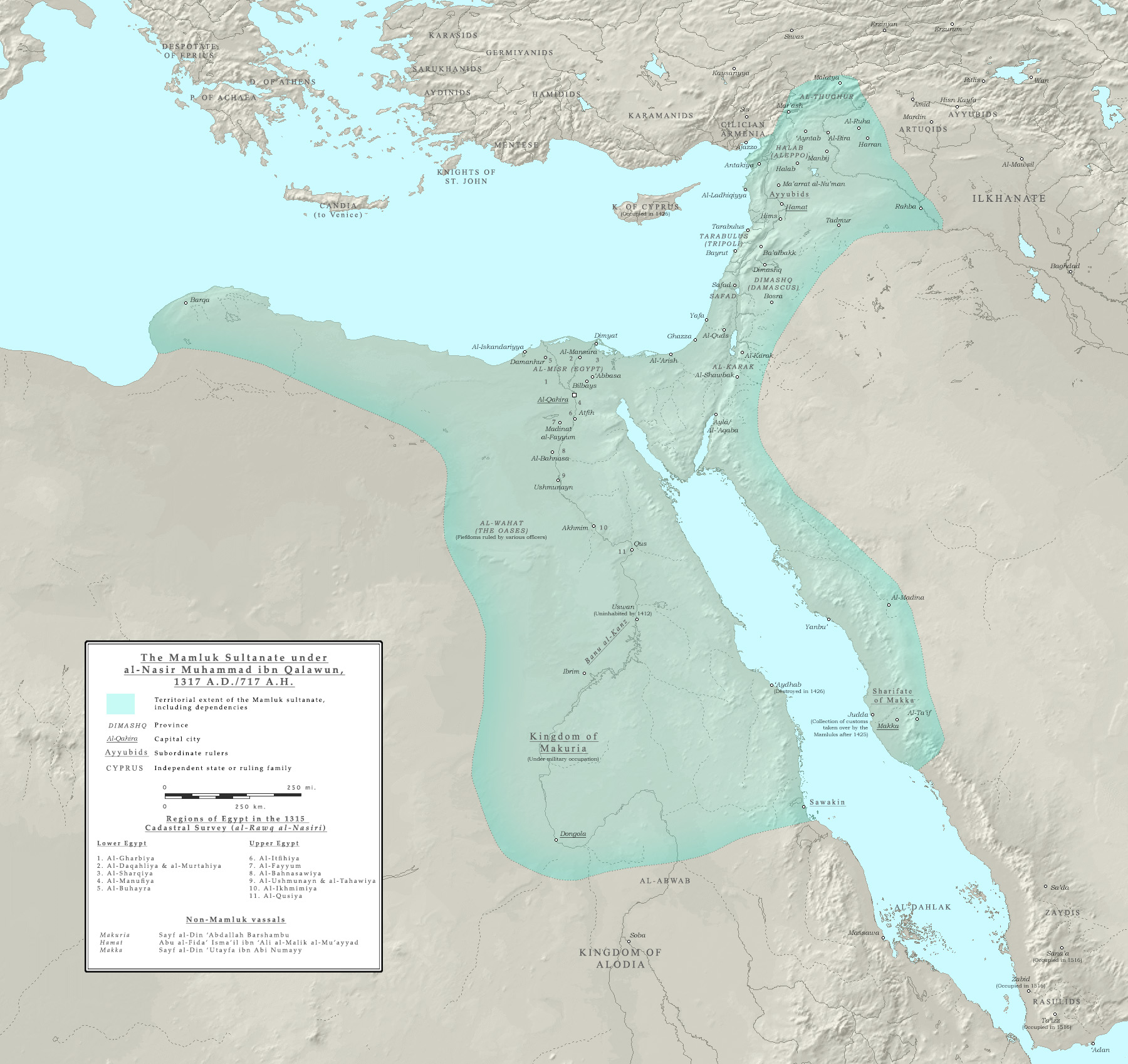
Map of the Mamluk sultanate during the third reign of al-Nasir Muhammad, 1317 AD, showing its political subdivisions and cities. Borders are approximate only.
The primary resource used is the Encyclopedia of Islam, New Edition; see the articles regarding the various places, dynasties and individuals featured in the map. The articles on Diyar Mudar, al-Sa'id and Nuba were also referenced.
Works cited:
- The Encyclopaedia of Islam. New Ed. 12 vols. with supplement and indices. Leiden: E.J. Brill, 1960-2005.
- "Europe in the Year 1300." Euratlas. Accessed 27 January 2016.
- Fakhry, Ahmed. The Oases of Egypt, Volume I: Siwa Oasis. Cairo: The American University at Cairo Press, 1973, pp. 96-97 (on the history of the Siwa Oasis).
- Holt, P.M. The Age of the Crusades: The Near East from the eleventh century to 1517. London: Routledge, 2013. ISBN 978-0-582-49302-5, pp. 133-36 (on Mamluk intervention in Makuria, along with the 1317 expedition to 'Aydab and Suakin).
- Holt, P.M. Early Mamluk Diplomacy (1260-1290): Treaties of Baybars & Qalawun with Christian Rulers. Leiden: E.J. Brill, 1995. ISBN 90-04-10246-9, pp. 74-78, 97-98 (copies of treaties which include lists of Mamluk territorial possessions).
- Al-Khazraji, 'Ali ibn al-Hasan. The Pearl-Strings; A History of the Resuliyy Dynasty of Yemen, Volume I. Trans. J.W. Redhouse. Ed. E.G. Browne, R.A. Nicholson and A. Rogers. Leyden: E.J. Brill, 1906 (on the history of the Yemen and Mecca).
- Nicolle, David. Mamluk 'Askari 1250-1517. Illus. Peter Dennis. Great Britain: Osprey Publishing, 2014. ISBN 978-1-4728-0352-8, p. 4 (containing map of the Mamluk sultanate).
- Peters, F.E. Mecca: A Literary History of the Muslim Holy Land. Princeton: Princeton University Press, 1994. ISBN 0-691-03267-X, pp. 148 ff. (on Mamluk activities in Mecca).
- Porter, Venetia Ann. The history and monuments of the Tahirid Dynasty of Yemen 858-923/1454-1517. PhD Thesis, Durham University, 1992, pp. 119 ff. (on the Mamluk intervention in the Yemen).
- Sinclair, T.A. Eastern Turkey: An Architectural and Archaeological Survey, Vol. IV. London: The Pindar Press, 1990, pp. 218-19 (on the status of Mamluk Jazira).
- Tsugitaka, Sato. State and Rural Society in Medieval Islam: Sultans, Muqta's and Fallahun. Leiden: E.J. Brill, 1997. ISBN 90-04-10649-9, pp. 135 ff. (regarding the rawk al-Nasiri; p. 138 contains the subdivisions of Egypt at this time); pp. 67-68 (on the oases of Egypt).
- Wiet, G. E.J. Brill's First Encyclopaedia of Islam, 1913-1936, Volume IV, 'Itk-Kwatta. Leiden: E.J. Brill, 1993. ISBN 90-04-09790-2, p. 904 (on the political status of the Wahat).
- Ziadeh, Nicola A. Urban life in Syria under the early Mamluks. Westport: Greenwood Press, 1953, pp 11-12 (on the administrative divisions of Syria).
Licencja:
Warunki licencji:
Creative Commons Attribution-Share Alike 4.0
Więcej informacji o licencji można znaleźć tutaj. Ostatnia aktualizacja: Fri, 10 Dec 2021 08:31:27 GMT